
TODAY: .02″ of rain at Reid Airport today breaks our 124 day dry spell, daytime high only at 97
TONIGHT: Clear skies and calm conditions, temps staying in the upper 80s and low 90s most of the night
TOMORROW: Heat returns with daytime highs in the triple digits and breezy winds picking up in the afternoon
FRIDAY: Windy with gusts upwards of 40 mph possible, temps still in the low triple digits with dry conditions leading to elevated fire concerns
THIS WEEKEND: Temperatures in the low to mid 90s Saturday and Sunday with lots of sunshine, windy on Saturday as fire weather concerns linger before winds calm a bit on Sunday
________________________________________________________
After not seeing measurable precipitation at Harry Reid International Airport for more than four months, our dry spell came to an end on Wednesday!
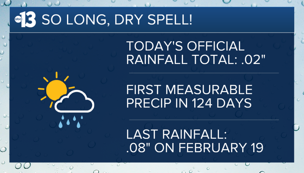
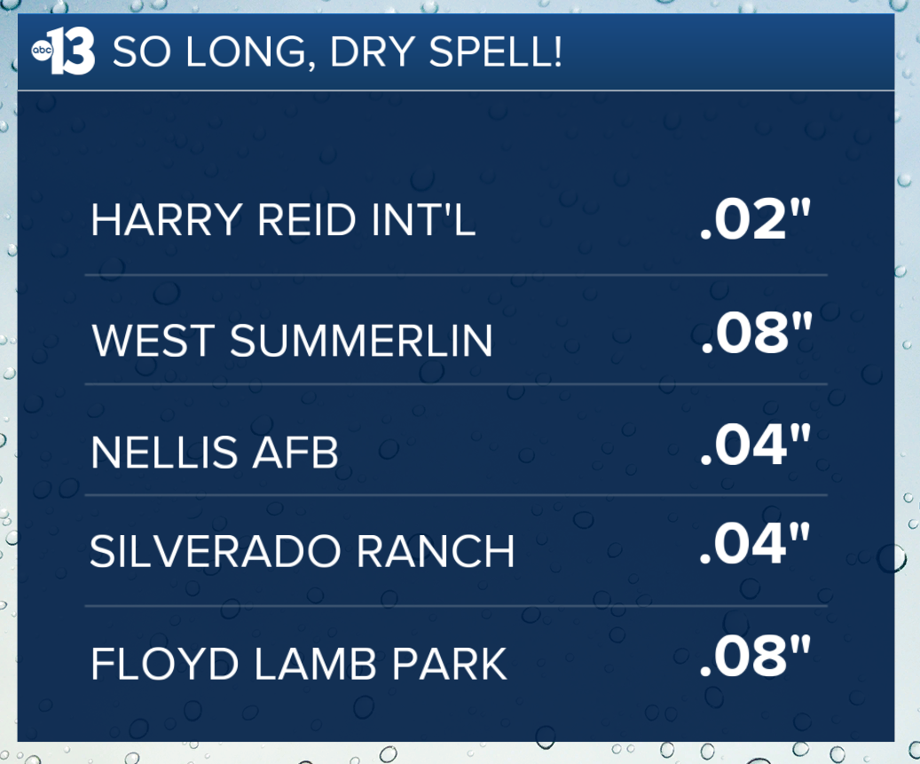
The airport recorded .02″ of rain today after active weather moved through the Las Vegas Valley this morning, bringing sprinkles to several neighborhoods the last time we saw measurable rainfall was 124 days ago, when .08″ of rain was recorded on February 19.
It may not sound like a lot, but when we’ve gone that long without rain, we’ll take anything we can get! Our yearly rainfall total is now .51″, which is well below normal we should be above two inches by this time of year.
Fun fact: this is only the sixth time it’s rained on June 24 in Las Vegas on record, according to our friends at the National Weather Service the most we’ve ever seen on this date was .10″ in 2009.
Storms moved east of us by the afternoon, which made for a calm but muggy evening, with humidity levels staying around 25%, but the cloud cover and active weather actually kept temperatures lower than anticipated.
Our daytime high at the airport today was 97, which is the first time with temps below triple digits in two weeks, when we hit 98 on June 9.
The dry heat returns tomorrow, though, when our forecast highs are expected near 105 with clear skies and breezy conditions.
Winds will pick up tomorrow evening and into Friday and Saturday, when wind gusts are expected between 30 and 40 mph, with gusts exceeding 40 mph possible some areas in Southern Nevada could see gusts closer to 50 mph, too.
The hot, dry and windy conditions on Friday and Saturday have resulted in the National Weather Service issuing a Fire Weather Watch for Friday morning through Saturday night, which means that any new fire start will likely take off quickly, and conditions for crews on pre-existing fires will be challenging. There’s a chance this Fire Weather Watch could be elevated to a Red Flag Warning once we get closer to the weekend.
The good news, though, is that the winds are on the leading edge of a considerable low pressure system hovering around the Pacific Northwest that will reach down into our neck of the woods, so temperatures could be 10 to 15 degrees below normal through Sunday daytime highs in the low to mid 90s and overnight lows in the 60s and 70s.
Temperatures are set to return to the triple digits by the middle of next week, as we’re expected to be back above normal by the time we’re reaching the Fourth of July holiday weekend.


